
Unlocking the power of satellite imagery for nature conservation
Satellite imagery is transforming conservation. By allowing scientists and practitioners to take an inventory of Earth’s surface and measure changes, we can now understand ecosystem dynamics at a level of detail like never before.
Published 09 September 2022
Satellite imagery is already enabling ecologists and conservationists to supplement and, in some use cases, even supplant traditional conservation research methods. This ranges from the rapid detection of deforestation to mining, locating wildlife colonies and other illegal activities causing negative changes to the landscape.
Plethora of benefits
The benefits of monitoring ecosystems and species from space are vast including:
- Allowing information to be collected in repeatable and standardized ways over time. For example, satellites and AI can detect plastic waste sites as small as 5 by 5 metres, creating an interactive “living” map of plastic pollution in near real-time.
- Surveying large spaces in short periods, repeatedly. For example, satellite images revealed that the Earth lost 4,000 km2 of its tidal wetlands over the past 20 years.
- Collecting information that is typically inaccessible to scientists. For example, a new colony of 1.5 million Adélie penguins, which stayed hidden for nearly 3,000 years, was detected in a pan-Antarctic survey that investigated every single cloud-free satellite image of the southern continent.
- Capturing a snapshot of a large area. This eliminates species miscounts that can happen when surveys are done by a human in an aeroplane who might go over the same area, or when objects of interest move from one transect (a natural feature or section of earth where observations are made or measurements taken for conservation monitoring) to another.
- Being unobtrusive, it requires no human presence, eliminating the risk of disturbing surveyed species and habitats.
- Surveying cross-border areas without requiring multiple national civil aviation permissions.
Conservation use cases for terrestrial protected area management
We’re uniting Airbus Foundation’s donated satellite imagery, with insights from our conservation field partners to explore the value of high-resolution satellite imagery for multiple conservation purposes including:
-
Locating endangered species in hard-to-reach areas
Coupling Airbus' Pleiades Neo satellite imagery with NTT Ltd.’s AI-powered solution, we’re also locating endangered species in hard-to-reach areas. By guiding conservationists on ‘where to look’ in satellite imagery, teams can identify wildlife hotspots and map species’ movements and connectivity of their changing territories across borders. This is helping create heat maps of species movement across reserves to enable conservationists to strategically apply resources to protect them - which is important when working across such large areas.
-
Capturing vital ecosystem information
By mapping water resources, human settlements, grasslands and invasive plant species from space, more informed sustainable management plans can be adapted to deal with changing climate-driven events and changing natural resources. This will better support local communities and conservation activities.
-
Detecting poaching incidents from space
Using Airbus’ pioneering 30cm high-resolution satellite imagery, we helped Madikwe Game Reserve identify a tragic poaching incident. Very sadly, two rhino carcasses were detected in the imagery, helping to understand the time of death and assisting criminal intelligence in the incident investigation.
-
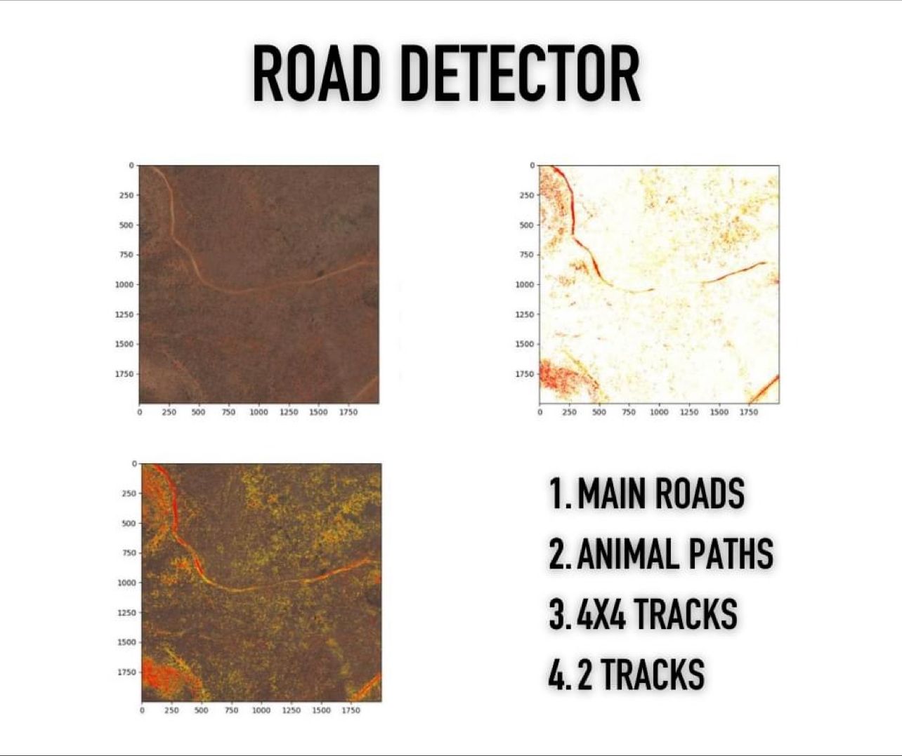
Mapping roads and creating up-to-date maps
Airbus satellite imagery is also helping ground teams monitor and manage the balance between tourism and conservation, alongside security. Annual satellite captures are helping create up-to-date reserve maps. This new visibility is also enabling managers to decide where to deploy and relocate resources and anti-poaching technologies, such as cameras to provide 24/7 monitoring of weak spots so rangers can get an early warning of threats.
Additionally, the identification of new and changing road networks – gives teams early warnings of potential extraction activities, including poaching, charcoal burning and bush clearing. This will help the team understand where better connectivity is needed within the park, alongside which roads are encroaching into species strongholds, helping managers prioritize where to close off or repair roads.
Supporting conservation efforts across more protected areas
Advancing this exciting connectivity between science, conservation and technology, our most recent project with Airbus Foundation has taken satellite images of the extensive Lorian ecosystem for Northern Rangelands Trust (NRT). This high-resolution satellite imagery of 1900 km2 has been sent to NRT researchers to plan conservation activities. These will give a baseline to measure ecosystem recovery over the next ten years for NRT and partners' conservation projects. The project will use the data to define new protected areas, where research will survey species, and categorize and map vegetation types, including the status of the invasive Prosopis juliflora tree, alongside hydrology channels and human settlements.
Furthermore, Kenya government agencies including Museum Kenya, Kenya University and the Kenya Wildlife Service will also work with NRT to use insight from this imagery for planning mitigation of human-wildlife conflict events between elephants, lions and local people. This will help establish wildlife corridors for species and communities to co-exist and thrive together. 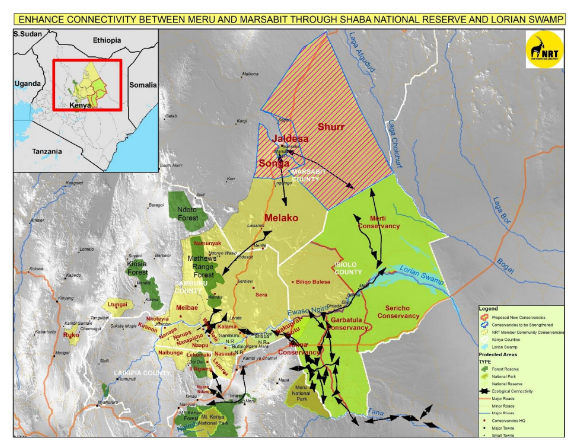
Conservation challenges of using satellite imagery
There are still many challenges facing conservationists when using satellite monitoring. Firstly, the size of satellite imagery for processing is huge - often too large for the field team's laptops to manage whilst needing specialist software to handle them. However, in some cases, visualization can be done via streaming access, which is much lighter in terms of image size. Secondly, several factors out of the user's control create a large variability in the quality of satellite imagery, including cloud cover, satellite orbit timings, incident angles and lighting.
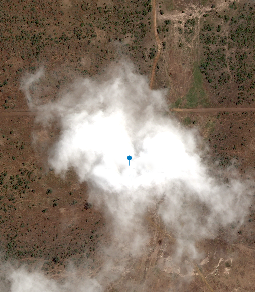
Fig 1: Pléiades Neo © AIRBUS DS (2022)
Fig 1 shows imagery from a recent wildlife survey conducted via satellite, where unfortunately cloud cover masked important sightings in this Game Reserve. At the time of satellite image capture, ground teams picked up wildlife sightings at these coordinates. On a day of 97% cloud-free cover, frustratingly this small cloud was the only one obscuring the main objects of interest.
Our partners are working on documenting the pitfalls and successes in applying these methods to real-world situations.
What’s next?
We are thrilled to be working with the following partners for the ongoing exploration of using satellite imagery for nature conservation in these areas. Watch for upcoming reports on our deeper investigation of specific use cases, new conservation applications and trials.
We are thankful for:
- AirBus Foundation for tasking Pléiades Neo and donating high-res satellite imagery.
- NTT Ltd engineers for developing wildlife detection algorithms and a pipeline to process imagery and deliver results, for field teams to review outputs.
- Microsoft for funding and providing computational resources through their AI4E programme.
- Northern Rangelands Trust and Madikwes Futures provided resources to collect GPS wildlife sighting data from the field to ground truth and validate results. For their ongoing collaboration participation in discovery workshops to explore the art of the possible, new use cases and validate against conservation objectives.
Altogether, we’re equipping dedicated conservation teams with effective tools to aid nature’s recovery and halt wildlife decline.