![]()

Integrating VHR Imagery and GPS collar data to map Andean bear movement and conflict zones
Authors | Ruthmery Pillco Huarcay (Conservación Amazónica) and Japheth Kimeu (CCF)
- State of species
- Ecosystem management
- Little is known about the elusive Andean bear’s movements and behaviour in its remote habitats. This first-of-its-kind study reveals patterns of bear movement and habitat selection, crucial for mitigating human-bear conflict.
- The Andean bear has lost over 75% of its historical range and is increasingly threatened by habitat loss, human-wildlife conflict and expanding human activity.
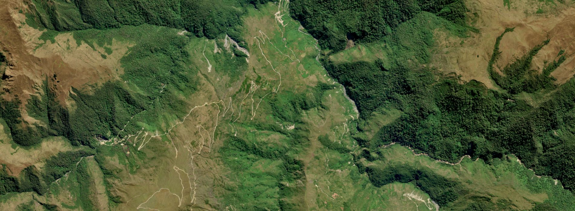
- High-resolution 30cm Pleiades Neo satellite imagery and GPS data from six collared bears were used to overlay bear movement data, with fine-scale habitat maps and human pressures across 953 km² of the Manu Biosphere Reserve.
- Bears primarily selected forests and stunted forests near rivers, avoiding densely populated areas, and overlapped with livestock in grazing shrublands and grasslands, revealing key conflict hotspots.
- Findings can guide community-led conservation, including habitat restoration, creation of wildlife corridors, and targeted conflict mitigation led by local leaders and indigenous women.
Objectives
1. Characterise Andean bear movement and habitat selection to inform species and habitat management plans.
2. Identify high-risk areas to mitigate conflict between humans, livestock and bears.

3. Create maps to support future community engagement and education to reduce conflict.
Introduction
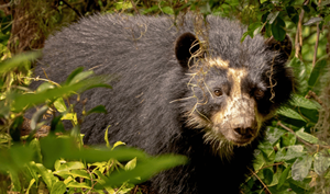
Little is known about the movement and behaviour of the elusive Andean bear (Tremarctos ornatus), particularly in the remote and inaccessible regions it inhabits. Yet understanding its behaviour is critical. The Andean bear has been particularly hard hit, experiencing one of the most severe range contractions recorded for any large carnivore—an estimated 75.2% loss of its historical distribution (Wolf & Ripple, 2017). This dramatic decline has left it among South America’s most threatened and least-studied large mammals, highlighting an urgent need to uncover its movements and how it interacts with a rapidly changing landscape.
As an adaptable, omnivorous species, the Andean bear can persist in a remarkable array of environments, from tropical dry forests to high Andean grasslands. However, its habitat use and selection is closely tied to the availability of forest cover, water sources, rugged terrain, and critically, the level of human disturbance within the landscape.
Rapid land-use changes, including agricultural expansion, burning and human–wildlife conflict, continue to threaten the long-term survival of the species. Its distribution across the Andes Mountains is highly fragmented, largely due to habitat loss, which restricts movement and disrupts historic dispersal routes critical for maintaining gene flow. This isolation of subpopulations can reduce genetic diversity, increase inbreeding and weaken the species’ ability to adapt to environmental changes or emerging threats. With only an estimated 2,500–10,000 mature individuals remaining (Rojas-Vera Pinto, Bautista and Selva, 2022), habitat degradation, fragmentation and conflict-driven mortality remain the most pressing challenges to its survival.
Study Area
This study is set in the Kosñipata–Carabaya Key Biodiversity Area of the Manu Biosphere Reserve in southeast Peru, a region positioned where the Andean and Amazonian watersheds meet. Recognised for its remarkable biodiversity, it supports the Andean bear alongside other threatened species such as the dwarf deer (Mazama chunyi), puma (Puma concolor), Andean fox (Lycalopex culpaeus), and Andean cat (Leopardus jacobita).
Forest loss has accelerated over the past two decades, averaging around 11 km² per year. Major drivers include wildfires, agricultural conversion, illegal logging and illegal mining.
Methodology
Data
The analysis utilised very high-resolution (VHR) satellite imagery from Airbus Pleiades Neo, with a spatial resolution of 30 cm, covering a total area of 953 km². The imagery was captured between October 2024 and June 2025, providing a detailed and up-to-date representation of the study landscape. As many parts of the Andean bear’s range are cloud forests, obtaining cloud-free images was challenging, and only tiles meeting strict quality criteria were included in the analysis.
In addition to the satellite imagery, ancillary vector data were incorporated, including rivers, towns, and protected areas, obtained from the National Database of Peru. These datasets provided essential contextual information for habitat and anthropogenic features across the study area.
All raster and vector datasets were uploaded to Google Earth Engine (GEE) for preprocessing and analysis. Individual image tiles from Pleiades Neo were mosaicked to create a single continuous raster image of the study area. This mosaicked image served as the base for landcover classification, distance calculations, and resource selection function (RSF) modelling, enabling spatially explicit assessment of bear habitat use and environmental predictors across the entire landscape.
Analysis
Landcover classification
To characterise habitat availability within the study area, we performed a landcover classification using Pleiades Neo high-resolution satellite imagery. Based on spectral embeddings and ancillary data, we distinguished three primary landcover classes: cloud forest, stunted forest, and grassland. The classification accuracy was assessed visually and through overlay with ground-validated points, confirming that the main vegetation types were captured effectively.
Bear Movement Data
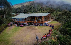
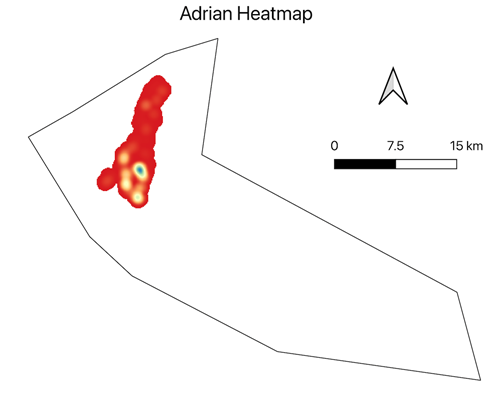
To examine habitat use and selection, we overlaid GPS collar data from six individual bears onto the classified landcover map. Each bear’s movement points were plotted against the landcover classes, revealing distinct patterns of habitat utilisation and bear behaviour. We also analysed a sub-set of data to interpret their movement in both day and night across the three major habitats to determine which habitats were selected for resource use in the study area. Movement data on Andean Bears was gathered by Ruthmery Pillco and her team based out of Wayqecha Biological Station run by Conservación Amazónica.
 |
 |
 |
 |
 |
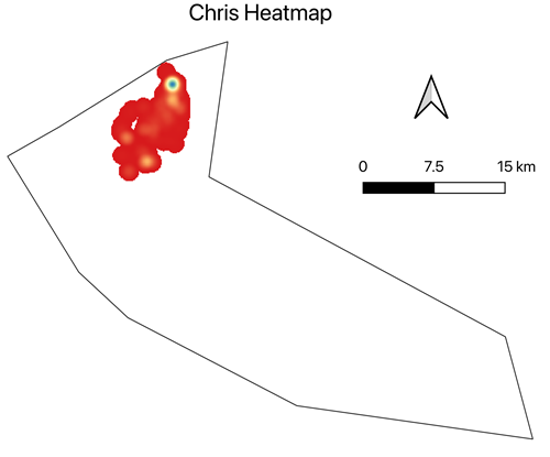 |
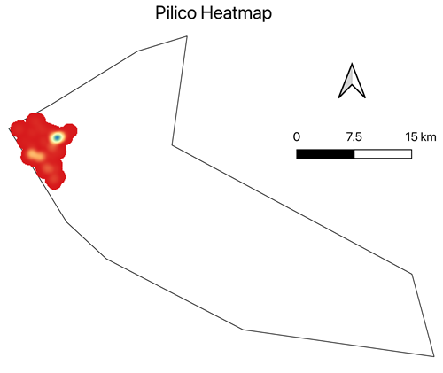
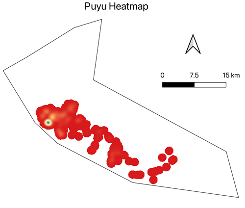
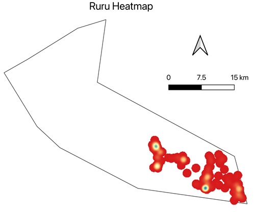
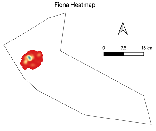
Figure 1: Heat maps of GPS locations for individual collared bears
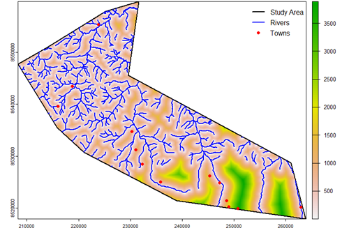
Distance layers were also generated for each point, distance to rivers and distance to towns, derived from river and town shapefiles. These covariates provided additional environmental context, capturing bear accessibility to water and anthropogenic disturbance.

Figure 2: Heat map of combined GPS locations from all collared bears, illustrating spatial patterns of habitat use and areas of overlap among individuals
Habitat selection modelling
We fitted a binomial mixed-effects Resource Selection Function (RSF) using the glmmTMB framework to quantify the effects of landcover type, population density and proximity to rivers and towns on habitat selection. The model included a random intercept for each bear to account for repeated observations and individual variation.
Results
Bear movement
Analysis of collar fixes indicates that bears most frequently used cloud forest habitat during both daytime and nighttime periods. During the day, 62.7% of all fixes occurred in cloud forest, followed by grasslands (27.1%) and stunted forests (10.2%). A similar distribution was observed at night, with 61.9% of fixes in cloud forest, 26.4% in grasslands, and 11.8% in stunted forests. Overall, cloud forest accounted for 4,107 of 6,595 total fixes, reflecting its dominant use across the 24-hour cycle.
However, these proportions represent habitat use and likely reflect the relative availability of cloud forest within the study area. High use does not necessarily indicate selection. Grasslands were used consistently, while stunted forests accounted for a smaller proportion of total fixes. The frequent use of forested habitats aligns with the dietary ecology of the Andean bear, which consumes a high proportion of plant material. In high-Andean grasslands (puna), terrestrial bromeliads of the genus Puya constitute an important seasonal resource, which may explain the regular, though proportionally lower, use of grassland habitats.
Resource Selection Function (RSF) Model
The resource selection function (RSF) model, which accounts for habitat availability, revealed that landcover type significantly influenced space use. Using cloud forest as the reference category, stunted forest was positively selected (β = 0.64, p < 0.001), indicating a higher relative probability of use compared to cloud forest. In contrast, grassland did not differ significantly from cloud forest (β = 0.05, p = 0.36).
These results suggest that although cloud forest was the most frequently used habitat in absolute terms (cloud forests are the most abundant habitat type), bears exhibited stronger selection for stunted forest when habitat availability was considered. Among continuous predictors, selection probability decreased with increasing population density (β = −0.28, p < 0.001) and increasing distance to rivers (β = −0.39, p < 0.001), indicating preference for areas closer to water and with lower human density. Selection probability also decreased with increasing distance to towns (β = −0.12, p < 0.001), suggesting relatively greater use of areas nearer settlements, a pattern that may reflect landscape configuration rather than attraction to human activity per se.

Figure 3: Influence of land cover (cloud forest, stunted forests and grassland) factors on bear space use
| Distance to rivers | Distance to towns | Population density |
 |
 |
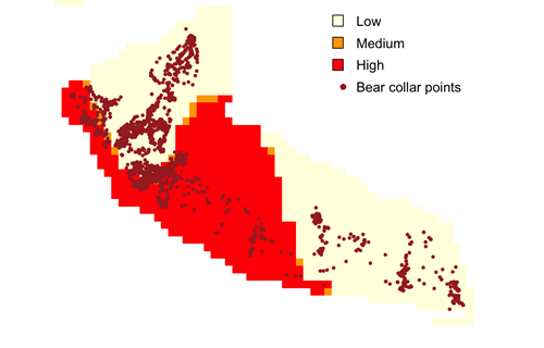 |
Figure 4: Influence of environmental factors on bear space use
Habitat use
Our analysis indicates clear differences in how the species used habitats across the landscape. After accounting for habitat availability in the Resource Selection Function model, stunted forests located closer to rivers and in areas of lower human population density showed higher relative probability of use, suggesting these environments form important components of the species’ core range.
Cloud forest habitats were used frequently in absolute terms, likely reflecting their greater availability within the study area, but they were not selected more strongly than other habitats when availability was considered. Grassland areas showed comparable levels of selection to cloud forest, indicating they function as supplementary habitats rather than being disproportionately favoured or avoided.
Overall, patterns of habitat use were shaped by vegetation type and proximity to water sources, with bears more likely to occur in less densely populated areas. These findings highlight the importance of considering both habitat availability and landscape context when interpreting space-use patterns.

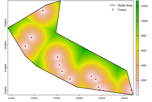
Figure 5: Habitat use across the landscape, showing areas of high and low use
Conclusion
The integration of high-resolution satellite imagery, ancillary spatial data, and GPS collar information has provided a more detailed, finer-scale understanding of bear habitat preferences and behaviour within the study landscape. This analysis offers Conservación Amazónica a framework to inform habitat protection, human-wildlife conflict mitigation, and land-use planning, particularly in areas where human activities overlap with key bear habitats.
By identifying zones of high bear selection that coincide with human activity, Conservación Amazónica can strategically prioritise conservation interventions to reduce habitat encroachment. Grassland areas commonly used for cattle grazing emerge as potential hotspots for human-wildlife conflict. Implementing targeted outreach, grazing management strategies, and community engagement in these areas can help mitigate conflicts and safeguard critical bear habitats.
Overall, this study highlights the value of combining high-resolution remote sensing with animal movement ecology to support evidence-based conservation planning in the Manu Biosphere Reserve, providing actionable insights for both habitat management and community-oriented conflict reduction.
*Note: These are initial analyses and will receive deeper ecological analysis in Ruthmery Pillco Huarcaya’s doctoral dissertation.
Conservación Amazónica - ACCA
Use science, technology and strategic actions to conserve and protect more than 5 million hectares of the Amazonian Andes in southern Peru.