![]()

Community Coexistence for Endangered Ethiopian Wolves in the Bale Mountains National Park, with AI-driven Settlement Mapping
Authors | Yacob T. Tesfaldet, Nji T. Ndeh, Getachew Mulualem (Ethiopian Biodiversity Institute)
- Ecosystem extent
- Ecosystem management
- Bale Mountains National Park (est.1969) is a unique high-altitude ecosystem and refuge for the endangered Ethiopian wolf (Canis simensis).
- Fewer than 500 wolves remain, threatened by habitat loss due to agriculture and grazing, firewood extraction, road fatalities and diseases such as rabies, spread from domestic dogs.
- AI-driven mapping showed human settlements inside the park increased tenfold between 2019 and 2024, mainly by pastoralist communities. Farmland expanded by 42%, leading to habitat fragmentation and disruption to wildlife corridors.
- This mapping data, awareness and education were shared with 200 residents across five local communities, and are expected to support better land management and community-led wildlife conservation.
- Further targeted actions are needed to halt the rapid human encroachment identified in the Bale Mountains National Park’s biodiversity and critical habitats.
Objectives
1. Quantify human settlement and farmland encroachment into the Bale Mountains National Park using satellites and AI, to target community coexistence initiatives for Ethiopian Wolf conservation.
2. Evaluate AI model efficacy for land-use classification in remote conservation areas.
3. Share map outputs, awareness and education with communities to promote community-led conservation and stakeholder engagement.
Introduction
Established in 1969, Bale Mountain National Park (BMNP) is home to Ethiopia's most important Afroalpine ecosystem. It shelters approximately 67% of the remaining endangered Ethiopian Wolf (the world’s rarest wild canids, with only about 500 left) — making it a crucial stronghold for the survival of the species.
Key drivers of population decline include habitat loss and fragmentation from farmland expansion and livestock grazing, overuse of natural resources (especially firewood collection), road accidents and infectious diseases such as rabies and canine distemper virus (CDV), often spread by domestic dogs.
Traditional ground-based monitoring approaches lack the coverage and consistency needed to track these threats across the BMNP. This study fills critical knowledge gaps by using a new approach that combines satellite imagery with artificial intelligence (AI). The AI tool, Mask R-CNN, was used to detect settlements, while SAM, adapted with Low-Rank Adaptation, was used to map farmland on high-resolution satellite images from 2019 and 2024. This created step-by-step methods for tracking landscape changes in places where data is scarce.
Local communities participated in validating the maps, educational activities and workshops across five villages. This data-driven, community-led approach combined technical tools with local knowledge, creating practical insights for conservation teams. These findings provide baseline information to guide policy and adaptive management in areas where people and wildlife share the land.
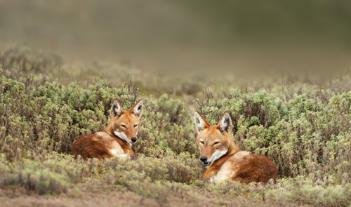
Figure 1: Ethiopian Wolf, the rarest wild canid species in the world
Study Area
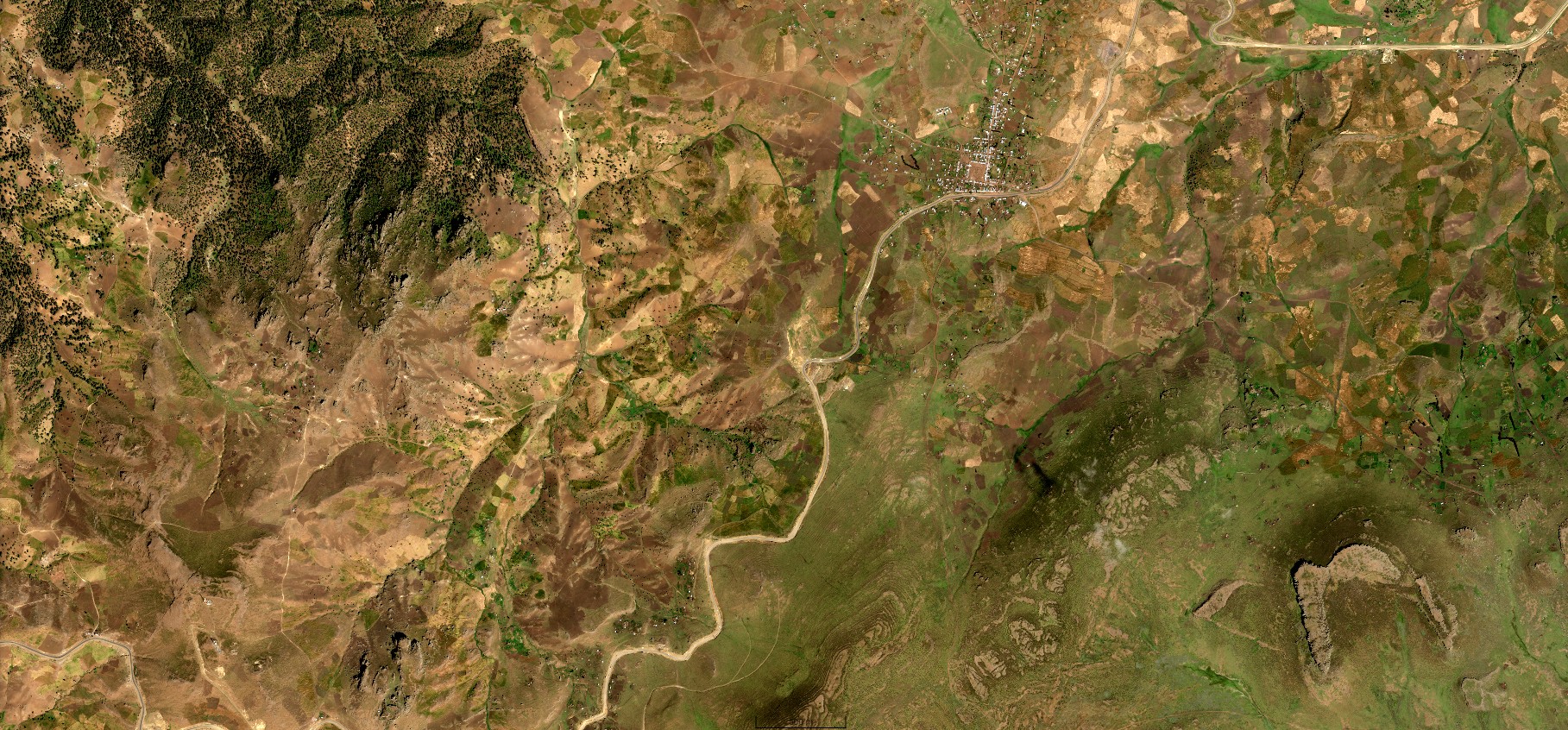
BMNP encompasses 2,200 km² of Afroalpine landscapes in Ethiopia's Oromia Region, representing the largest contiguous Afroalpine ecosystem in Africa (Figure 2). Web Valley, a UNESCO World Heritage Site within BMNP, constitutes the core Ethiopian Wolf habitat at 3,000-4,377 m elevation. Our analysis focused on a 10 km buffer zone around Web Valley, capturing the primary human-wildlife interface.
The study region exhibits distinct ecological gradients from Afroalpine moorlands to montane forests, supporting endemic species assemblages. Adjacent communities practice mixed agro-pastoral systems, cultivating barley, wheat and traditional crops at altitudes up to 3,200 m. Demographic pressure and climate variability have intensified resource competition, driving encroachment into protected areas. The region's complex topography and cloud cover patterns present unique challenges for satellite monitoring, necessitating robust algorithmic approaches.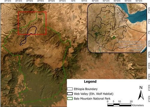
Figure 2: Study area - Bale Mountains National Park
Methodology
Data
The study employed a multi-stage methodology integrating remote sensing, machine learning and community engagement to analyse human encroachment in Bale Mountain National Park (BMNP). Satellite data acquisition began with high-resolution imagery from Pleiades 1A (55.6 cm resolution) and Pléiades Neo (30 cm resolution) for 2019 and 2024, respectively.
Analysis
Settlement detection data analysis
A 10 km buffer zone around Web Valley was defined using Arc GIS Pro to focus analysis on the Ethiopian Wolf’s critical habitat, while minimising computational load. For settlement detection, a Mask R-CNN model was trained on manually annotated satellite imagery, where rooftops were labelled as polygons. The model’s backbone (ResNet-50) was fine-tuned with focal loss to address class imbalance caused by sparse settlements. Hyperparameters, including learning rate (0.001) and anchor scales, were optimised for small structures (<50 m²), while post-processing removed false positives (e.g., rock formations mimicking rooftops) through size filtering and shape analysis.
Farmland delineation data analysis
Farmland delineation utilised the Segment Anything Model (SAM) adapted with SamLoRA architecture. The pre-trained SAM image encoder was frozen, and Low-Rank Adaptation (LoRA) layers (rank=4) were inserted into transformer blocks to enable efficient domain-specific learning with minimal parameters. The prompt encoder was bypassed, relying on default positional embeddings to capture generalised textures, while the mask decoder was reconfigured to output class-indexed masks for multi-season farmland segmentation. Training leveraged manually digitised farmland polygons validated against ground-truth data from aerial surveys and field observations.
Model performance was evaluated using precision, recall and F1 scores, with cross-validation ensuring robustness across varying topographies. All datasets were integrated in Google Earth Engine and ArcGIS Pro for spatiotemporal analysis, enabling quantification of encroachment rates and identification of high-risk zones. This approach combined technical precision with visual insights, ensuring actionable outcomes for conservation planning.
Change detection results
Human settlement
A temporal comparison of maps from 2019 and 2024 reveals a dramatic proliferation of human settlements within and surrounding the Bale Mountains National Park (BMNP). The analysis, which focused on the park, the Web Valley, and a 10 km buffer zone, documents an alarming rate of expansion over these five years.
The number of settlements within the BMNP boundary surged from approximately 388 to 3,506 — a staggering ~10-times increase (Figure 3 below). This trend was mirrored within critical zones: settlements in the Web Valley itself grew from 11 to 165, while the surrounding 10 km buffer zone saw an increase from 903 to 6,180 structures.
Figure 3: Settlements within Bale Mountain National Park increased nearly tenfold from 387 in 2019 to 3,506 in 2024, with most remaining standalone and minimally overlapping with farmland
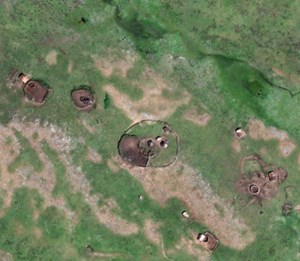
Spatially, this expansion is most concentrated in the northeastern sections, with settlement clusters intensifying and encroaching deeper into the park's interior (Figure 4). This pattern indicates a significant and growing human footprint, likely driven by population pressure and a lack of enforcement, which poses a severe threat to the park's conservation objectives.

Figure 4: Settlement expansion is most concentrated in the northeast, with clusters spreading deeper into the park
Human settlements are growing inside and around the park, and their impacts are directly tied to the two main types of livelihoods: agriculturalists (farmers) and pastoralists (herders):
Agriculturalists (farmers)
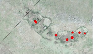
In areas close to existing villages, new settlements often appear alongside cleared farmland. This pattern suggests the settlers are agriculturalists. Their practice of clearing land for crops destroys the habitat of the giant mole-rat, which is the primary prey of the endangered Ethiopian wolf.
Pastoralists (herders)
In contrast, settlements deeper within the park and in the Web Valley are usually enclosed by fences, a sign that they belong to pastoralist communities. While these settlements do not significantly overlap with farmland boundaries, they pose another critical threat: diseases such as rabies and canine distemper carried by domestic dogs can spread to Ethiopian wolves.
Combined threats
Together, the impacts of habitat loss from farming and disease risks from herding create a serious and urgent challenge to the long-term survival of the park’s unique biodiversity.

Figure 5: Snapshots of encroachment across Bale Mountains National Park
Changes in farmland encroachment
Even though a smaller percentage of settlements were classified as agriculturalists (5% in 2019 and 11% in 2024), their impact is greater.
Farmland encroachment around these agricultural settlements expanded substantially, growing from 10.69 km² in 2019 to 15.16 km² in 2024, a 42% rise, dominated by smallholder cultivation of staple crops. SamLoRA demonstrated strong performance in farmland delineation, achieving a precision of 0.77 and recall of 0.89, excelling at capturing linear field patterns typical of agricultural plots. However, commission errors arose in areas where shrublands exhibited spectral similarities to farmland, highlighting limitations in texture differentiation. The 10 km buffer zone around Web Valley emerged as the most affected area, with escalating habitat fragmentation from farmland encroachment threatening Ethiopian Wolf corridors.
This encroachment suggests growing pressure on Wolf habitat from agricultural practices, likely driven by human population growth. The increased presence of houses, particularly along the fringes of the buffer zone and within close proximity to core conservation areas, further underscores the urgency to enforce the park’s integrity.
Map output and community engagement
These findings informed strategies for community workshops, targeted education initiatives, and community-led, land use planning to improve coexistence and mitigate further degradation of this ecologically sensitive landscape.
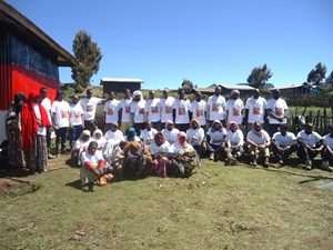
Partners launched an ambitious community engagement program called Peaceful Co-existence. The initiative targeted five key villages (kebeles) and involved more than 200 residents through participatory workshops designed to build trust and strengthen relationships with community leaders.
Residents took part in interactive mapping sessions that used infographics to visualise patterns of land encroachment and habitat loss. At the same time, structured surveys measured local awareness of conservation challenges and coexistence policies.
A central focus of the campaign was two-way dialogue. Researchers spoke with both farming (agriculturalist) and herding (pastoralist) communities to better understand local perspectives on the challenges they face and how these intersect with the survival of the Ethiopian wolf. A recurring concern voiced by residents was the spread of disease from domestic and stray dogs, particularly rabies, which mirrors the study’s finding of increased pastoralist settlements bringing wolves into closer contact with dogs.
The sessions also provided practical conservation education. Residents learned about biodiversity, the ecological importance of BMNP, current threats to wildlife and hands-on methods for protecting species. This program has built on existing voluntary park monitoring committees across the kebeles, which already meet every 15 days to review their activities, strengthening community-led conservation efforts.

Figure 7: Bridging knowledge and communities - researchers and farmers join forces to protect Ethiopia’s wolves through dialogue and community action.
Conclusion
This study highlights the rapid human-driven transformation of Bale Mountains National Park, fueled by uncontrolled settlements and farmland expansion between 2019 and 2024, which threatens the ecological integrity of the Web Valley and demands urgent intervention. By combining satellite data, AI-powered analytics and community engagement, this research offers precise, actionable evidence to guide conservation policy. These metrics show a clearly defined crisis, giving policymakers a data-driven mandate to enforce land-use regulations, allocate resources more effectively and act without delay.
Community engagement proved equally critical, serving not only to bridge knowledge gaps but also to strengthen collaboration between researchers and local communities. Both researchers and community leaders emphasised the importance of expanding training programs to deepen participants’ skills and knowledge, while also fostering stronger partnerships with local authorities to build a more cohesive community network. Leveraging technology emerged as another key strategy to broaden outreach and increase engagement. At the same time, offering stronger incentives could enhance participation and commitment, and regular follow-up assessments would help ensure campaign goals are effectively met.
Feedback highlighted the need to expand efforts by scaling outreach through technology, strengthening partnerships with local authorities, and incentivising nature-positive, community-led monitoring. Integrating advanced monitoring with local stewardship establishes baselines for evaluating interventions and supports adaptive management. Future work should prioritise adaptive governance, sustainable livelihoods that align development with conservation and community empowerment to safeguard the Bale Mountains’ unique biodiversity for generations to come.
Chulalongkorn University
A leading creator of knowledge and innovations for the sustainable development of society.
Ethiopian Biodiversity Institute
Conserving biodiversity, promoting sustainability, fair benefit sharing and nationwide research and coordination.