![]()

AI-Powered Habitat Mapping in South Sudan’s Game Reserves
Authors | Chelsea Smith, Harriet Branson (Fauna and Flora)
- Ecosystem extent
- Two small game reserves, Bangangai and Bire Kpatuos, sit deep in South Sudan’s wilderness, containing valuable primary forest and grasslands, vital in supporting populations of endangered species such as bongo, pangolin, forest elephants and chimpanzees.
- Using AI and very-high resolution satellite imagery from the Airbus Foundation, this project aims to analyse the extent of critical habitats to support targeted conservation actions and support analyses on connectivity across the landscape.
- The project developed a deep learning model using over 3,000 manually drawn labels to create a highly detailed landcover map, classifying over 1 billion pixels across the two game reserves.
- The project has pulled into focus the work required at Fauna & Flora to integrate cutting-edge technology and data to better support on-the-ground conservation for greater impact.
- The landcover maps are essential inputs to understand the viability of these landscapes. These, coupled with additional biodiversity monitoring datasets, will provide deeper insights into how endangered species are using this landscape.
Objectives
1. Create detailed land cover maps of Bangangai and Bire Kpatuo Game Reserves, to build a baseline dataset, enabling assessment of conservation and livelihood impacts across the reserves.
2. Investigate how high-resolution imagery and AI can analyse potential deforestation drivers and evaluate the connectivity of these precious ecosystems.
3. Strengthening park management and expanding the Community Conservation Area using data-driven strategies.
Introduction
South Sudan is home to some of the world’s most significant wilderness landscapes, boasting vast herds of migratory antelope and habitats for globally threatened species. This extraordinary natural heritage places the country at the heart of global conservation priorities. Yet, these fragile populations face severe threats: decades of civil conflict left conservation efforts almost nonexistent and renewed stability has unfortunately fueled illicit activities such as poaching and unregulated grazing by migratory pastoralists.
Without effective management and community engagement, the survival of these ecosystems is at serious risk. Protecting them requires a combination of strong protected area governance and local empowerment to sustainably manage natural resources.
For more than a decade, Fauna & Flora has supported the Bangangai and Bire Kpatuo Game Reserves. Established in the 1930s, both reserves are now under intense pressure from poverty-driven poaching and subsistence activities. Adopting a holistic landscape approach, we promote stability and development through the creation of a Community Conservation Area (CCA) serving as a protective buffer around the reserves. Current priorities include strengthening park management and expanding the CCA using data-driven strategies. While biomonitoring has been carried out in the reserves, knowledge remains limited on biodiversity and landscape use within the CCA and in the corridors connecting the two reserves. This project set out to build a baseline dataset, enabling assessment of both conservation and livelihood impacts across the reserves and the CCA.
Study Area
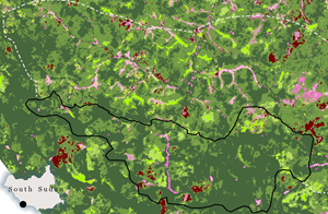
Located in southwest South Sudan along the border with the Democratic Republic of Congo, the Bangangai and Bire Kpatuo Game Reserves and surrounding Community Conservation Areas span 1,855.27 km².
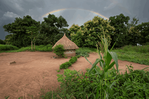
Though relatively small in scale, these protected areas provide essential irreplaceable primary forests and grasslands. The reserves support exceptional biodiversity and threatened ecosystems, including intact lowland forest and key habitat for the bongo (Tragelaphus eurycerus). They are also vital refuges for threatened forest mammals such as forest elephants, pangolins, chimpanzees and monkeys. In addition, Fauna & Flora-supported surveys in 2015 revealed the presence of new mammal species within the reserves, including pangolins, the golden cat and brush-tailed porcupine, further underscoring their global conservation importance.
 Figure 1: Bongo captured on a camera trap in Bangangai
Methodology and Analysis
Data
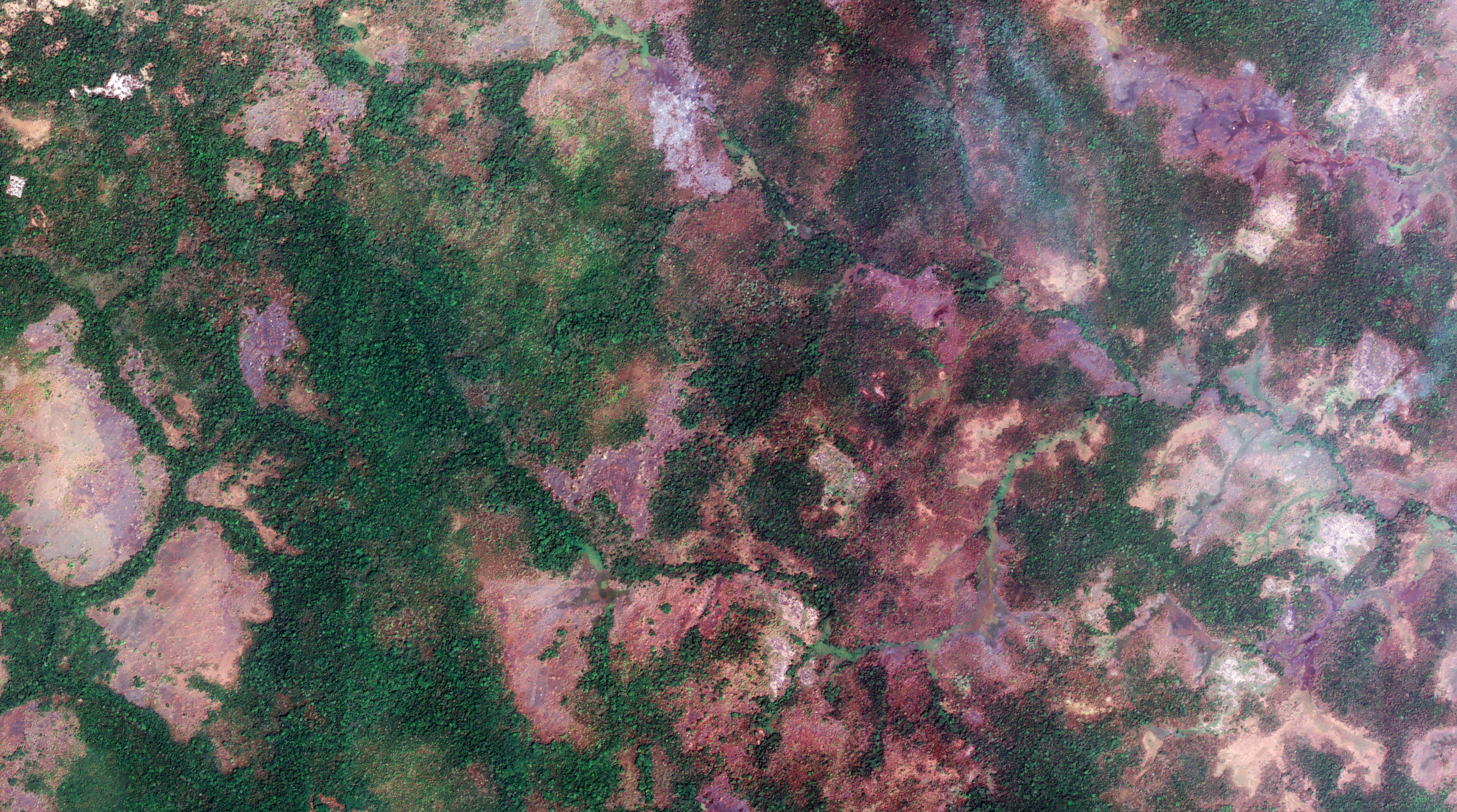
We used VHR 50 cm imagery from Airbus Pleiades captured in February 2024, South Sudan’s dry season.
Feature extraction
Working with site teams, mapping classes were first defined using the FAO Land Cover Atlas of South Sudan as a foundation, with the South Sudan team adding any missing categories. This process produced 12 broad classes and 25 detailed classes. During a 2.5-week field expedition in June 2024, Fauna & Flora’s South Sudan team collected 237 ground reference points supported by landscape photographs.
In addition, the team documented critical habitat features such as salt licks, visible signs of degradation or human activity and land cover types. These datasets were vital for enabling the technology team to interpret the landscape accurately and understand how different habitats appeared in satellite imagery. The information also guided image labelling efforts, while a portion of the ground reference data was reserved for validating the model outputs.
Model development
To analyse the satellite imagery, we worked with two HP ZBook Studio G11 Mobile Workstations, one equipped with 32 GB of RAM and the other with 64 GB. Instead of building custom Python models, we used this setup because access to cloud computing was limited and the workstations had memory restrictions.
The Deep Learning Libraries available in ESRI ArcGIS Pro v3.4 offered a practical solution. They allowed us to apply AI techniques for satellite image analysis in a way that can be replicated by other technical users, even those without coding experience. Within these libraries, we used tools such as Label Objects for Deep Learning, Export Training Data for Deep Learning, Train Deep Learning Model, and Classify Pixels Using Deep Learning to process and classify the imagery.
Model training: Building an accurate representation of the landscape
For training the deep learning model, we set a target of labelling up to 1% of the total image area across both game reserves. To ensure all land cover types were represented, the study area was divided into 100 x 100 m grid cells, with a random selection of cells chosen to provide balanced training coverage.
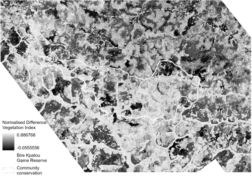
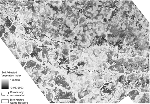
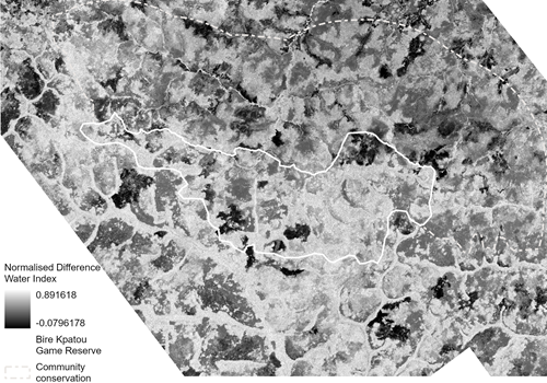
To support labelling, we generated a range of indices—including EVI (Enhanced Vegetation Index), SAVI (Soil Adjusted Vegetation Index), normalised burn ratio, texture and moisture. These indices were tailored to the specific habitats of each reserve, meaning the exact combination varied between sites. Using insights from literature and histogram analyses, we then applied thresholds to automatically detect certain habitat types, particularly helpful for identifying closed woody vegetation.
In addition to automated methods, more than 1,000 labels were manually digitised to refine accuracy. Finally, we calculated the total area for each label class to confirm that the dataset was both well-balanced and representative of the reserves’ diverse habitats.
Table 1: Indices/predictor variables for Bangangai Game Reserve
|
NVDI (Normalised Difference Vegetation Index) |
EVI (Enhanced Vegetation Index) |
 |
 |
|
NDWI (Normalised Difference Vegetation Index) |
GCLM Texture (Gray Level Co-occurrence Matrix Texture) |
 |
 |
Table 2: Indices/predictor variables for Bire Kpatuo Game Reserve
|
NVDI (Normalised Difference Vegetation Index) |
SAVI (Soil Adjusted Vegetation Index) |
 |
 |
|
NDWI (Normalised Differece Water Index) |
BAI (Burned Area Index) |
 |
 |
Validating the Models
The labelled data were exported as training chips and used to develop two segmentation models—PSPNet and U-Net—both built with a ResNet-34 backbone. Training was set to stop automatically once improvements plateaued, which occurred after 20 iterations for Bire Kpatuo and 17 for Bangangai.
The models were trained on Pleiades satellite imagery that combined red, green, blue and near-infrared bands, along with vegetation indices and GLCM texture values. To assess performance, accuracy was measured using both a confusion matrix and a visual review of the outputs.
Results
Bire Kpatuos results
The model was trained using 2,219 labelled samples across eight land cover classes. Training went through several iterations, with parameters and band combinations adjusted each time to boost accuracy. Among the two models tested, U-Net performed better than PSPNet, particularly when distinguishing between open-woody areas, woody vegetation and grassland within wetlands. That said, some challenges remained. The model occasionally confused burnt areas, seasonal wetlands and open-woody vegetation in wetland zones. The table below summarises the parameters tested and the corresponding accuracy scores for each run.
Table 3: Summary of model parameters tested and their corresponding accuracy scores across training runs
Model |
Parameters |
Accuracy |
|
PSPNet |
RGB, NIR |
76.8% |
|
PSPNet |
RGB, NIR, NDVI, SAVI, NDWI, BAI |
67.2% |
|
UNET |
RGB, NIR |
77.6% |
|
UNET |
RGB, NIR, NDVI, SAVI, NDWI, BAI |
80.4% |
The best model achieved an overall accuracy of 80.4% and was used to predict and classify the final habitat map of the study area.
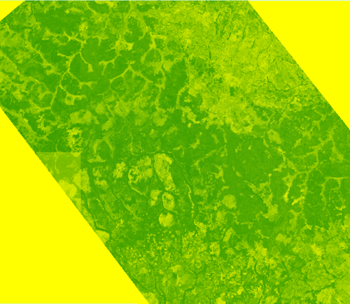
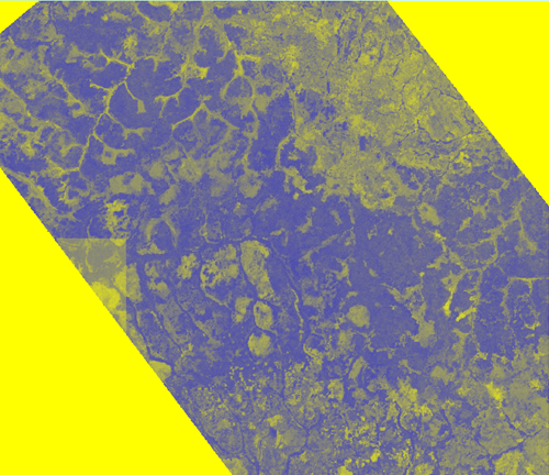
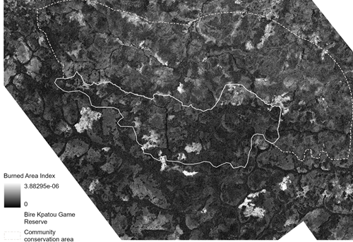
The final habitat map of Bire Kpatuo shows a large area of continuous closed woody vegetation, along with patches of open vegetation. Inside the game reserve and nearby CCA, seasonal wetlands are clearly visible, likely serving as important habitats and water sources for endangered species. Outside the reserve, there is less closed woody vegetation, and paths and buildings can be seen. Some small burned areas near villages may be linked to slash-and-burn farming practices.
Habitat Map of Bire Kpatuo

Figure 2: Bire Kpatuos Game Reserve land use land cover map
Bangangai Game Reserve Results
The model was trained using 1,098 labelled polygons across 12 land cover classes. After several rounds of refinement, the U-Net model achieved an overall accuracy of 84.5%, based on 500 assessment points and reliable ground reference data. U-Net outperformed PSPNet, particularly in identifying closed woody vegetation, bare soil and herbaceous crops, with users’ accuracy scores above 85%, demonstrating strong reliability for these habitats. Some challenges remain in distinguishing grassland, especially in burnt areas, where dry grass can look very similar. Grassland within wetlands and seasonal wetlands was generally classified well, although occasional confusion occurs between these two types due to their similar spectral signatures.
Table 4: Summary of model parameters tested and their corresponding accuracy scores across training runs
Model |
Parameters |
Accuracy |
|
PSPNet |
RGB, NIR |
58.3% |
|
PSPNet |
RGB, NIR, NDVI, NDWI, EVI, GLCM |
64.6% |
|
UNET |
RGB, NIR |
72.4% |
|
UNET |
RGB, NIR, NDVI, NDWI, EVI, GLCM |
84.5% |
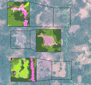
Habitat Map of Bangangai Game Reserve
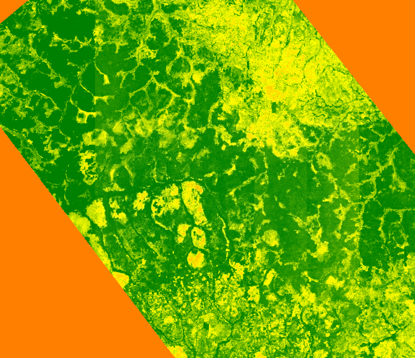
The results provide a detailed map of habitat cover in Bangangai Game Reserve, revealing that much of the area is dominated by closed woody vegetation. This includes a large, intact core forest and potential corridors for forest elephants and other key species, with over 100 km² classified as closed woody vegetation. In the southeast, crop fields are expanding into the reserve, likely cleared using slash-and-burn farming. The imagery also shows many palm trees spreading from plantations into forested areas. In the northwest, seasonal rivers create important swamp and wetland habitats during the rainy season, supporting a variety of wildlife.

Figure 3: Bangangai Game Reserve land use land cover map
Discussion
Map output and review
The two game reserves in South Sudan are still largely understudied, and the maps produced through this project fill an important data gap that previously limited other analyses. Planned ground patrols and camera trap surveys will add more information to help understand species richness, occupancy and connectivity in these areas, building on the foundation of this study.
In the medium term, we hope to work with species experts to develop connectivity models that show how key species move across the landscape and interact with nearby community conservation areas (CCAs). The maps of closed and open woody vegetation in both BGG and BK reveal critical habitat for forest elephants. By combining this with camera trap data and community reports, we can track elephant movements and provide targeted support to communities near these areas.
The data from BGG also highlights growing crop encroachment near and inside the game reserve. These crops have likely replaced closed woody vegetation, which is a vital habitat for forest elephants and bongos. Our South Sudan team is using this data to guide patrols, assess the extent of encroachment and explore where additional community engagement could help prevent further habitat loss. This analysis will also identify key wildlife corridors and inform where conservation resources should be focused.
Within the CCAs, the maps will guide community engagement by showing patterns of natural resources. This helps us support communities in managing resources sustainably.
Organisational learning
This project has been a huge learning experience for Fauna & Flora, especially as it’s the first time using AI-driven, very high-resolution satellite imagery. A few key lessons stood out:
Hardware and computing needs: It was discovered that running AI models in Python requires cloud computing and storage. Running the models locally also needs a powerful computer, plenty of memory and a good graphics card. While the workstations could process the imagery, run times ranged from 3 to 32 hours. This clearly highlighted the importance of having the right hardware and systems to support ongoing AI analyses.
Labelling and ground data: The project emphasised the value of high-quality labels and ground reference data. It’s better to have fewer, accurate labels than a large number of lower-quality ones. Aligning ground data collection with satellite imagery helps improve model validation. Local knowledge is also invaluable for interpreting the imagery, confirming results, and identifying important habitat areas for further investigation.
Staff time and planning: AI projects require significant staff time. Labelling, retraining models, adjusting parameters, validating results and sharing knowledge can take more time than the initial model training itself. Planning for this in advance, especially when applying for funding, ensures staff are properly resourced to manage the workload.
Conclusion
Access to Airbus’ 50 cm Pleiades imagery has allowed Fauna & Flora to produce the first AI-driven, very high-resolution land cover maps for Bangangai and Bire Kpatuos Game Reserves. Using deep learning libraries from Esri, we created detailed habitat maps that highlight intact forests and important wetlands, while also revealing emerging pressures like small-scale agriculture and slash-and-burn clearing. These maps are a vital tool for biodiversity monitoring, connectivity modelling and designing targeted conservation actions both inside and beyond the reserves.
The project also provided important lessons. Implementing AI solutions requires significant investment in staff time, computing resources and ground reference data. High-quality labels and local ecological knowledge proved just as crucial as choosing the right model. These insights emphasise the need to plan realistically for both human and technical resources when applying advanced technology in conservation.
Looking ahead, these land cover maps will support evidence-based work within the reserves and community conservation areas. They provide a strong foundation for future analyses, including connectivity, deforestation risk, and species occupancy, and will help strengthen advocacy for South Sudan’s unique biodiversity. At the same time, this work demonstrates Fauna & Flora’s capacity to harness innovative tools and shows how similar approaches can be applied across our wider conservation portfolio.
Fauna & Flora
Protecting the diversity of life on Earth, for the survival of species and habitats, the planet and people.